School Pupils in Osaka are Champions for Avoidable Deaths from Tsunamis
By: Hideyuki Shiroshita
The city of Izumiotsu, located in the central part of Osaka Prefecture, Japan, is a relatively small city with approximately 75,000 inhabitants. The city was once famous for its blanket industries, but now most companies have moved their factories overseas. At one point, 90% of Japanese blankets were produced in Izumiotsu. The former blanket factories have now been turned into apartment buildings, which have brought more residents from outside of the city. The location of the city is between Kansai International Airport and the city centre of Osaka. The residents can easily commute to Osaka’s city centre from Izumiotsu.
Izumiotsu is located along a coastline. It used to be a beach, but now it is a quay that serves as an important port for the Kansai region. From this port, it is possible to take a huge ferry boat to Kyushu Island. The sea brings a nice view to the residents of Izumiotsu. However, the sea has also brought on tsunamis. The central and local governments have revisited the tsunami prediction and have also recalculated damage from the tsunami after the 2011 triple disaster. The earthquake prediction indicated that the worst-case scenario would result in more than 2,000 deaths due to the tsunami. However, the prediction also indicated that if the people are prepared for the tsunami, then no one would die. This means that there would be enough time for an evacuation between the predicted earthquake and the tsunami. Quick evacuation is essential for the residents to avoid deaths.
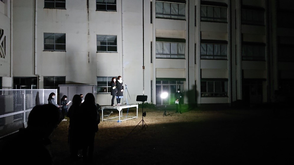
To disseminate this important information to the residents of Izumiotsu city, the school pupils of Hama elementary school decided to promote tsunami/disaster education in 2013. In 2020, led by ADN’s President, Dr Hideyuki Shiroshita, the 5th-grade pupils (10-11 years old) published Tsunami DRR newspaper, conducted mock drills to raise awareness amongst the residents, and developed a tsunami Augmented Reality (AR) to indicate tsunami risk.
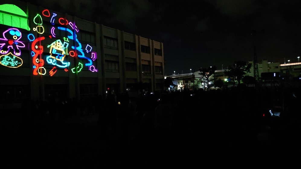
After the application of the tsunami AR, the pupils found that though demonstrating AR is helpful to show the tsunami risk, dissemination of the application is not simple. Based on this reflection, Dr. Hideyuki Shiroshita and the school pupils (currently 6th grade) decided to create projection mapping this year so that many people can watch the work at once.
The projection mapping of tsunami risk is a joint project of the faculties of Societal Safety Sciences and Informatics of Kansai University. The pupils’ projection work was displayed outside of a building on the 3rd of December 2021 and can be watched on YouTube. The projection mapping has been conducive to the current COVID-19 restrictions of gathering people inside a building. More than 200 people watched the projection work in open-air including the mayor, the superintendent of schools, and the leader of the Disaster Risk Reduction of Izumiotsu city.
After the display of the projection mapping, the pupils conducted a questionnaire survey. The findings of this survey revealed that more than 90% of the respondents learned about the tsunami risk and the importance of evacuation to reduce avoidable deaths from a tsunami.